2024 Atlantic Hurricane Season Outlook
Credit: NOAA


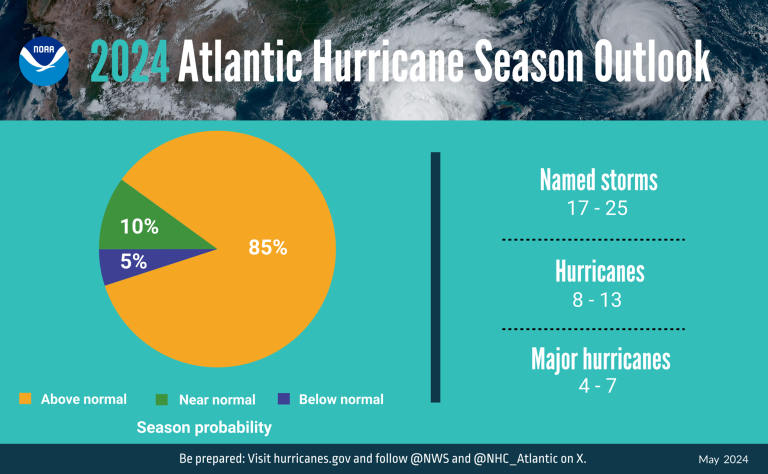
NOAA’s Climate Prediction Center forecasts a range of 17 to 25 named storms (average is 14). Of those, 8 to 13 are forecast to become hurricanes (average is 7), including 4 to 7 major hurricanes (average is 3). A major hurricane is category 3, 4 or 5 on the Saffir Simpson, with winds of 178 kmh/111 mph or higher.
The Atlantic hurricane season lasts from 1 June to 30 November and is carefully monitored by the World Meteorological Organization Tropical Cyclone Programme. There have now been eight consecutive years of above average activity. The last below normal season was in 2015.
“It takes just one landfalling hurricane to set back years of socio-economic development. For example Hurricane Maria in 2017 cost Dominica 800% of its Gross Domestic Product. Early warnings by the WMO community and improved disaster risk management have dramatically reduced fatalities, but Small Island Developing States in the Caribbean still suffer disproportionately,” said WMO Secretary-General Ko Barrett.
“This is why WMO and its partners have prioritized early warning action in small islands under the international Early Warnings For All initiative and will showcase the need for more coordinated and targeted investment in early warning systems at the forthcoming International Conference on Small Island Developing States,” said Ko Barrett, who coordinates WMO Early Warnings for All activities.
“We need to be especially vigilant this year due to near-record ocean heat in the region where Atlantic hurricanes form and the shift to La Niña conditions, which together create the conditions for increased storm formulation,” said Ko Barrett.
Sea level rise, worsened by storm surge, increases the potential risk for coastal communities. In recent years, we have observed more rapid intensification of tropical cyclones, which poses a significant challenge when it occurs near land, such as Hurricane Otis.
Between 1970 and 2021 tropical cyclones (the generic term which includes hurricanes) were the leading cause of both reported human and economic losses worldwide, accounting for more than 2 000 disasters.
However, the death toll decreased from more than 350,000 in the 1970s to less than 20,000 in 2010-2019. Reported economic losses in 2010-2019 were at 573.2 billion dollars.
2024 Atlantic Hurricane Season Outlook
Credit: NOAA
NOAA cited the near-record warm ocean temperatures in the Atlantic Ocean, which creates more energy to fuel storm development. The anticipated transition from El Niño to La Niña is another factor because La Niña tends to lessen wind shear in the tropics.
WMO will issue its next El Niño/La Niña outlook at the start of June.
This hurricane season also features the potential for an above-normal west African monsoon, which can produce African easterly waves that seed some of the strongest and longer-lived Atlantic storms. Finally, light trade winds allow hurricanes to grow in strength without the disruption of strong wind shear, and also minimize ocean cooling, according to the NOAA statement.
The WMO Regional Meteorological Specialized Center Miami (the US National Hurricane Center) takes the lead on issuing forecasts and warnings.
It envisages a number of improvements in forecast communications and the provision of forecasts and warnings for wind, rainfall, storm surge and flooding hazards, as well as impact assessments. Enhanced and sustained ocean observation networks were identified as critical to improve hurricane rapid intensification and track changes. These were discussed by the WMO Hurricane Committee at its annual session in March.
The WMO Hurricane Committee is also responsible for the rotating lists of tropical names used to communicate warnings and raise public awareness and preparedness.
Read the NOAA Hurricane Outlook
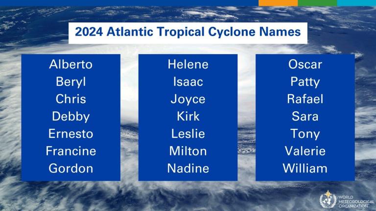
2024 Atlantic Tropical Cyclone Names
EIN Presswire does not exercise editorial control over third-party content provided, uploaded, published, or distributed by users of EIN Presswire. We are a distributor, not a publisher, of 3rd party content. Such content may contain the views, opinions, statements, offers, and other material of the respective users, suppliers, participants, or authors.